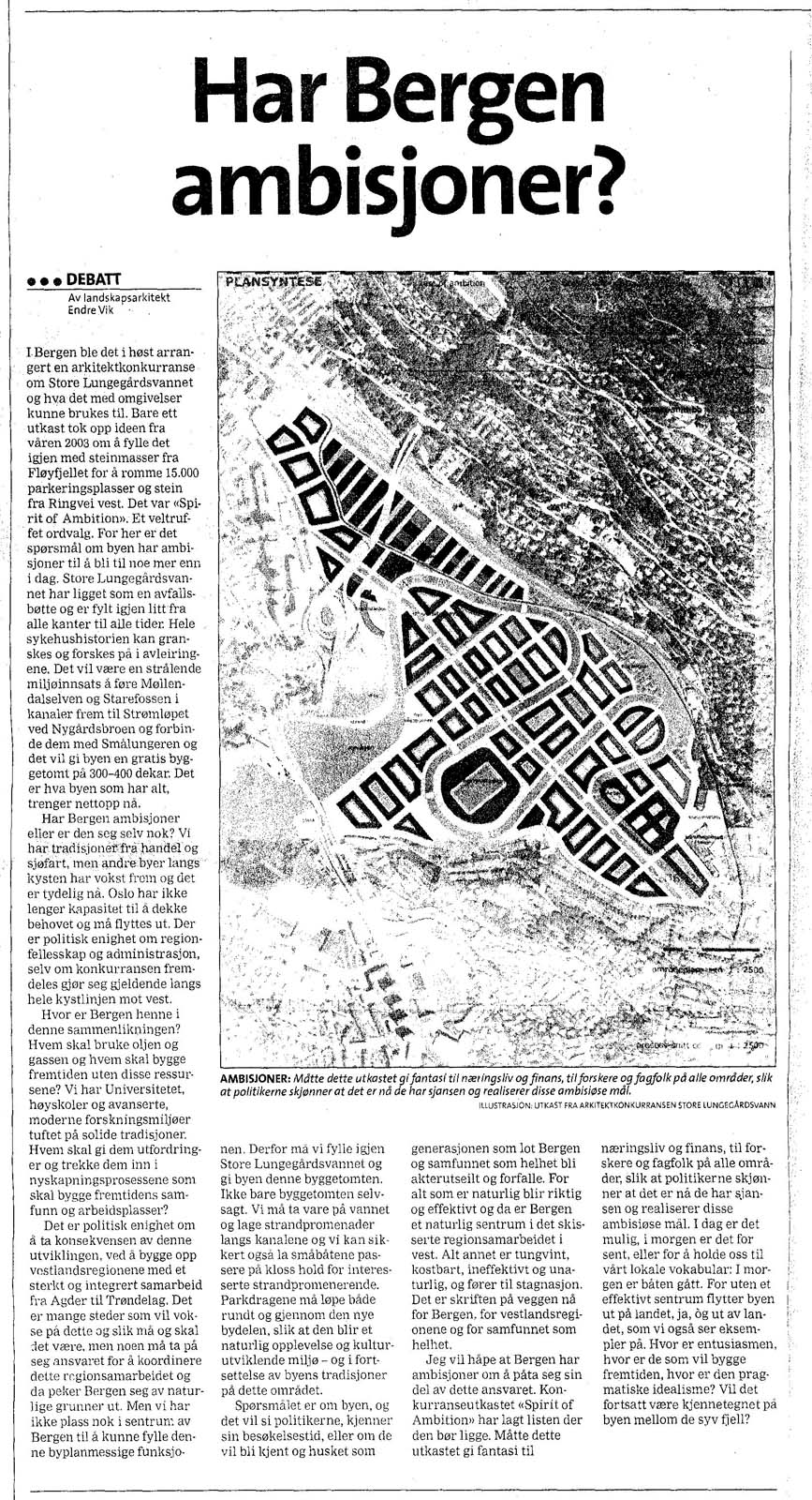
Urban Planning Competition - Store Lungegårdsvannet

View from Northwest
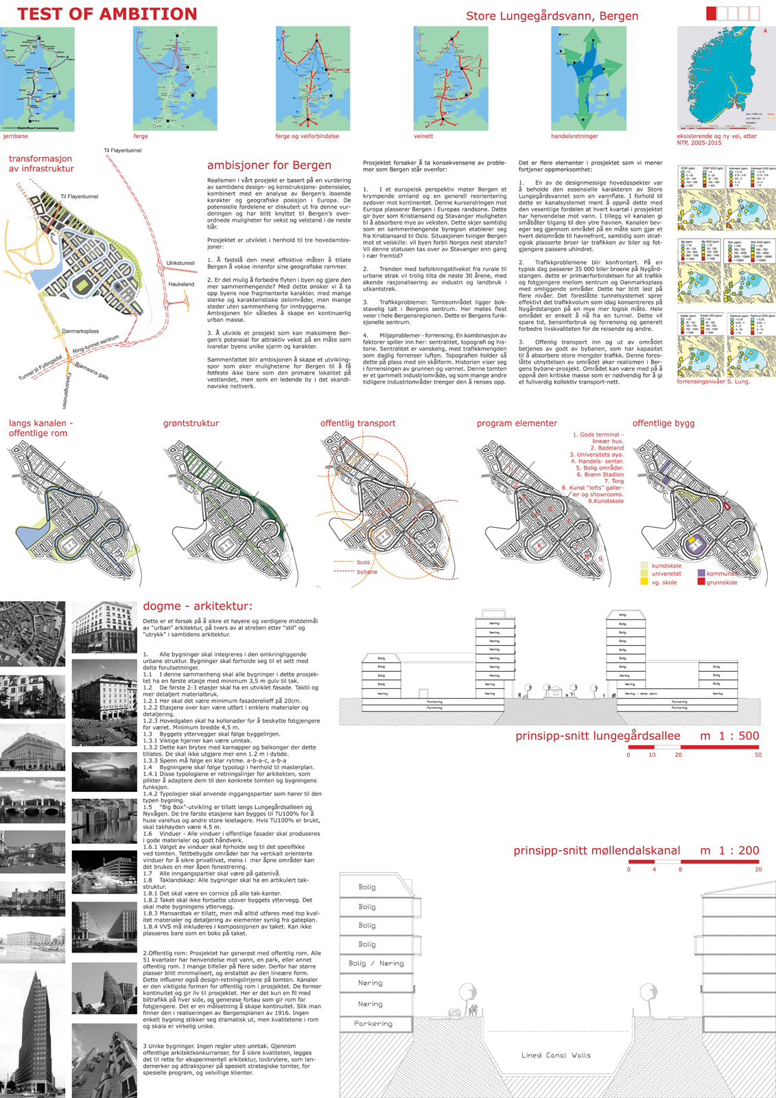
“A TEST OF AMBITION” – CITY PLANNING IN BERGEN, NORWAY – 2004
Note:
This project was an entry for a Planning Competition for Store Lungegårdsvannet in 2004 with Anders Melson.
Bergen, Norway is experiencing the shifts of scale that the 20th century brought. Bergen benefits from these changes due to the petroleum and tourism industries. However, the industries that were the historic base of Bergen’s economy have declined. Following the broadly western pattern of 20th Century development: transportation links and population migrations are moving slowly southward. Further, transportation corridors have shifted away from maritime to land based transit. These factors combine to move Bergen from a central transit point in the North Sea, to the periphery. The authors suggests that if Bergen wants to maintain its position as a regional city it must expand it center aggressively. Only by adding “weight” to its mass will it be able to combat the slow decline that is typical of many cities today.

Bergen in the World
Background:

Historical Bergen
Bergen, Norway was once the center of trade on the North Sea. A proud Hansa town, it was a way point at which fish came into land to be salted, and put in barrels. Timber from the forests of Western Norway was cut and exported to create the building materials of Europe. Hemp and Linen was imported and processed in to rope and sail cloth. It was a bustling spot with the occasional problem of over fishing or urban fires. Bergen - The Hansa City. It made its way thus, to the 20th Century.

Transportation Infrastructure 2004
The trade routes of the machine age changed life in Bergen. Rather than materials flowing in and out of its port, Bergen was suddenly bypassed. However, Bergen is a very ambitious city and would like to fight contemporary trends. This project is one attempt to address the trends of the late 20th and 21th centuries.
![maps [Converted]](http://static.squarespace.com/static/54184046e4b0096c901a8a6d/541972dee4b09ed94b654ea5/541972dee4b09ed94b654f2f/1396948165000/maps-Converted.png?format=original)
Trade Links Four Lane Roads:
If highways lead to growth then we can clearly see where Norway will be growing. (Red existing, Yellow Planned) Norway, like many Western Countries, is experiencing a population shift to the South. This is enhanced by exchange in Nordic Countries becoming increasingly triangulated between Oslo, Stockholm and Copenhagen, with Finland and the Baltic Countries functioning as a route east and Denmark as a link south. Thus, Bergen set out around 2000 to improve it situation in the years to come by holding a contest for the development of former industrial areas within the city: Store Lungegaardsvannet From a 2001 Planning document:
The plan area makes up a large area of potential for development of new building areas in close proximity to the city center. Arrangements for large recreational areas along the water is an essential part of the plan. Today, the areas are mainly used for industrial, warehouse, retail and offices with housing in the border zones against Kronstad Mount. Møllendal cemetery with the chapel, two motor associations and Lungegård Park built in 1997, is also within this area.
“Planområdet utgjør et stort arealpotensiale for utvikling av nye byggeområder i nær tilknytning til Bergen sentrum. Tilrettelegging for større rekreasjonsarealer langs vannet er en vesentlig del av planen. I dag er arealene i hovedsak nyttet til industri, lager, handel og kontorer med boliger i randsonene opp mot Kronstadhøyden. Møllendal gravlund med kapell, to motorbåtforeninger og Lungegårdsparkenopparbeidet i 1997, ligger også innenfor planområdet.”
There is an overarching goal to pave the way for a new urban structure of public spaces linked to the major communication arteries, promenade along the lake and walking path along river. The plan seeks to preserve the area’s character by highlighting important landscape features, culture, historical buildings and structures and making them widely available and visible.
“Det er et overordnet mål å legge til rette for en ny, urban struktur med offentlige byrom knyttet opp mot viktige kommunikasjonsårer, strandpromenade langs vannet og tursti langs elven.
Planen søker åbevare områdets egenart ved å fremheve viktige
landskapstrekk, kulturhistoriske bygg og strukturer samt å gjøre disse allment tilgjengelig og synlig.”

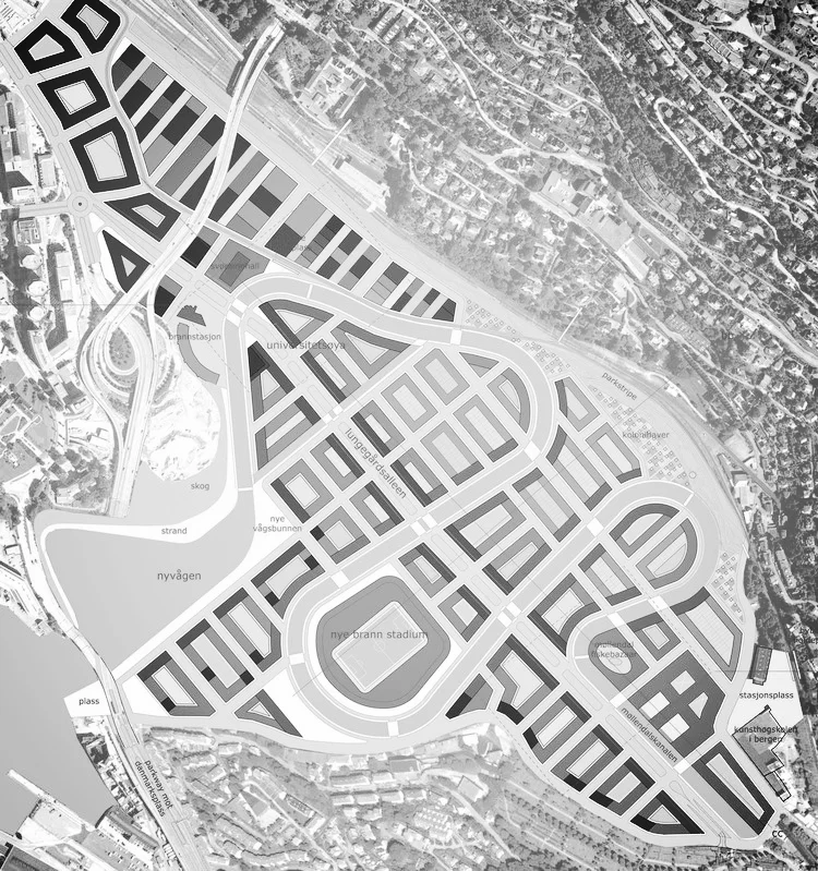
Use Areas, Map and Bergen Center, Bergen's 1916 post fire plan inserted into the project area for reference.
Site:
The site was the area around Store Lungegaardsvannet. This area includes the Train Station, Freight Terminal, Boat Yards, and various infrastructure elements. The bay is named after the farm of Lungegården, the estate of the Danish nobleman Vincens Lunge. In the Middle Ages, the bay was named Alrekstadvågen, after the royal farm of Alrekstad. In the 1930s, the bay, and the area surrounding it, was an attractive recreation for the inhabitants of the city, with boat harbors and beaches. Starting in the 1950s, the bay was seen as a resource for the city to cover the acute need for free land. As a result, there have been several fill-ins of parts of the lake, mainly on the northern shore. (from Wikipedia, link)
Primary Goals:
- To determine the most effective way to allow Bergen to grow within the confines of the areas geography:
- Is it possible to improve the flow of the city and to make it more contiguous (By this we mean to address the issue of the city being somewhat fractured and having several distinct parts which do not readily coalesce for its inhabitants. Forming so called “continuous Urban Tissue”).
- Design a development which would maximize Bergen’s potential for attractive growth in a way that preserved the unique charm of the city.
- To provide "weight" for Bergen's center that will anchor it both regionally and globally.
Our overall ambition is to create a development path which raises the opportunity for Bergen to gain anchorage not only as the primary location in West Norway, but as a premiere city in Scandinavia commensurate with its history and “brand” recognition.

Movement of Urban Center, Traffic Diagram, Overall Plan

View of Main Street Looking North
Result:
In the end this project created space for 25,000 new residents in Bergen center, accompanied by 25,000 new jobs / workspaces. This effectively doubles the population of the center of Bergen allowing the effective use of the resources located there. A project of this nature would also slow the necessity for expansion of suburban areas, along with their associated larger Carbon footprint. (link)

Program Elements
Design Goals:
- Maintain Scale of City Blocks – the small scale of Bergen’s urban structure helps create a pleasant pedestrian atmosphere.
- Give as much access to the water as possible.
- Use a standard “European Scale” scale for building heights. (ca. nine stories)
- Locate “attractors” in this area such as to develop this area as a complementary part of the center.
Site Organization:
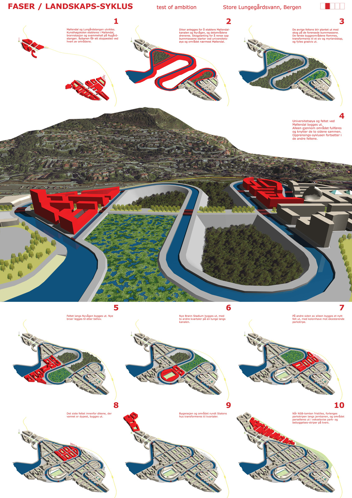
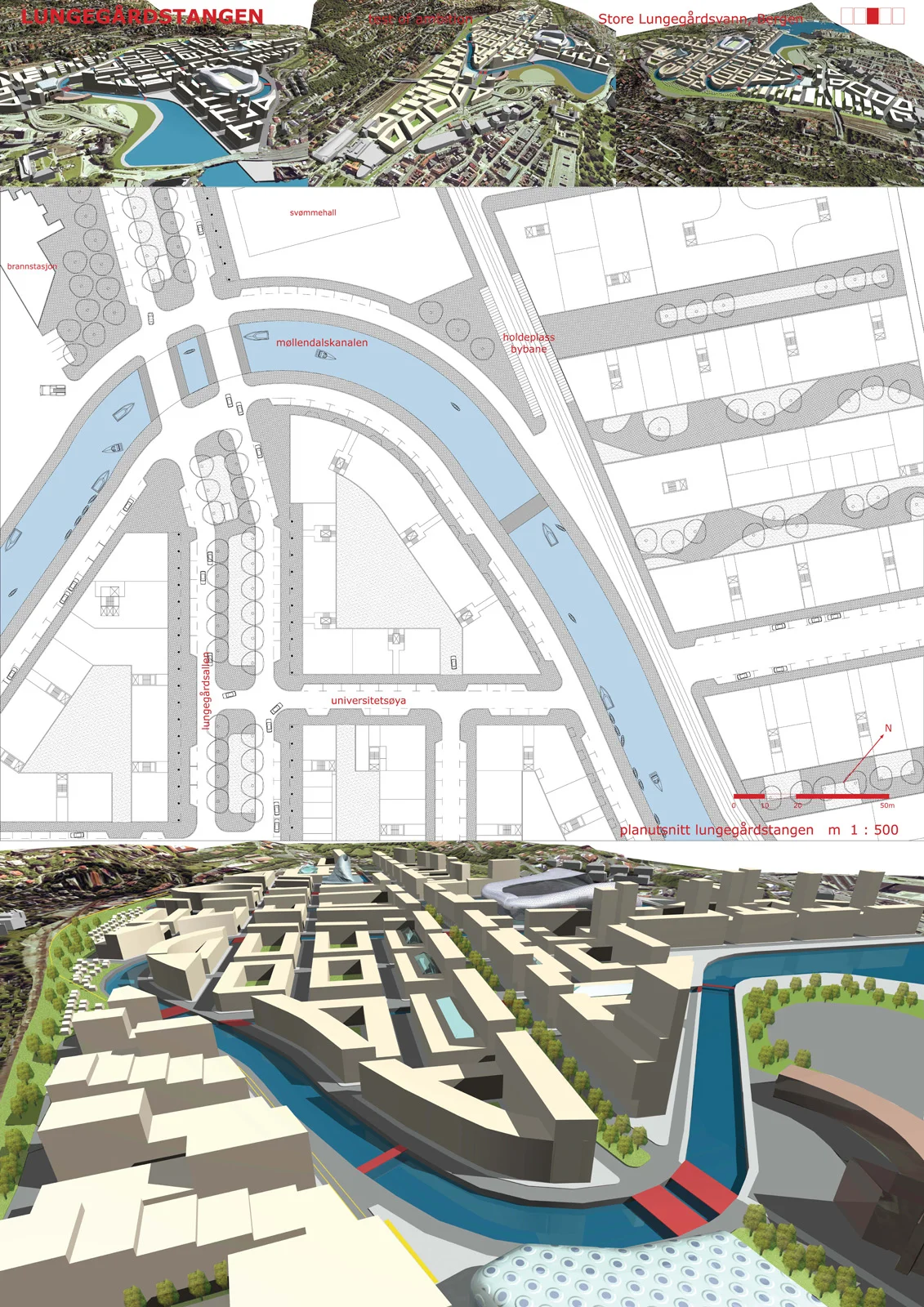
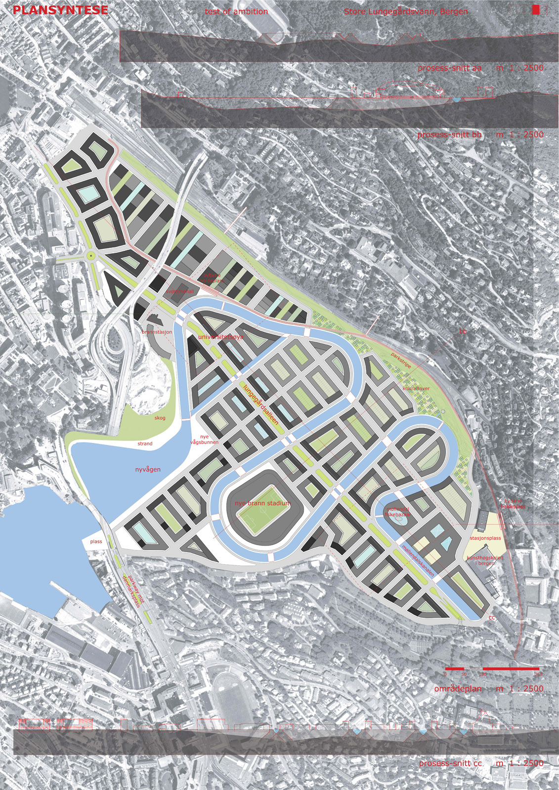
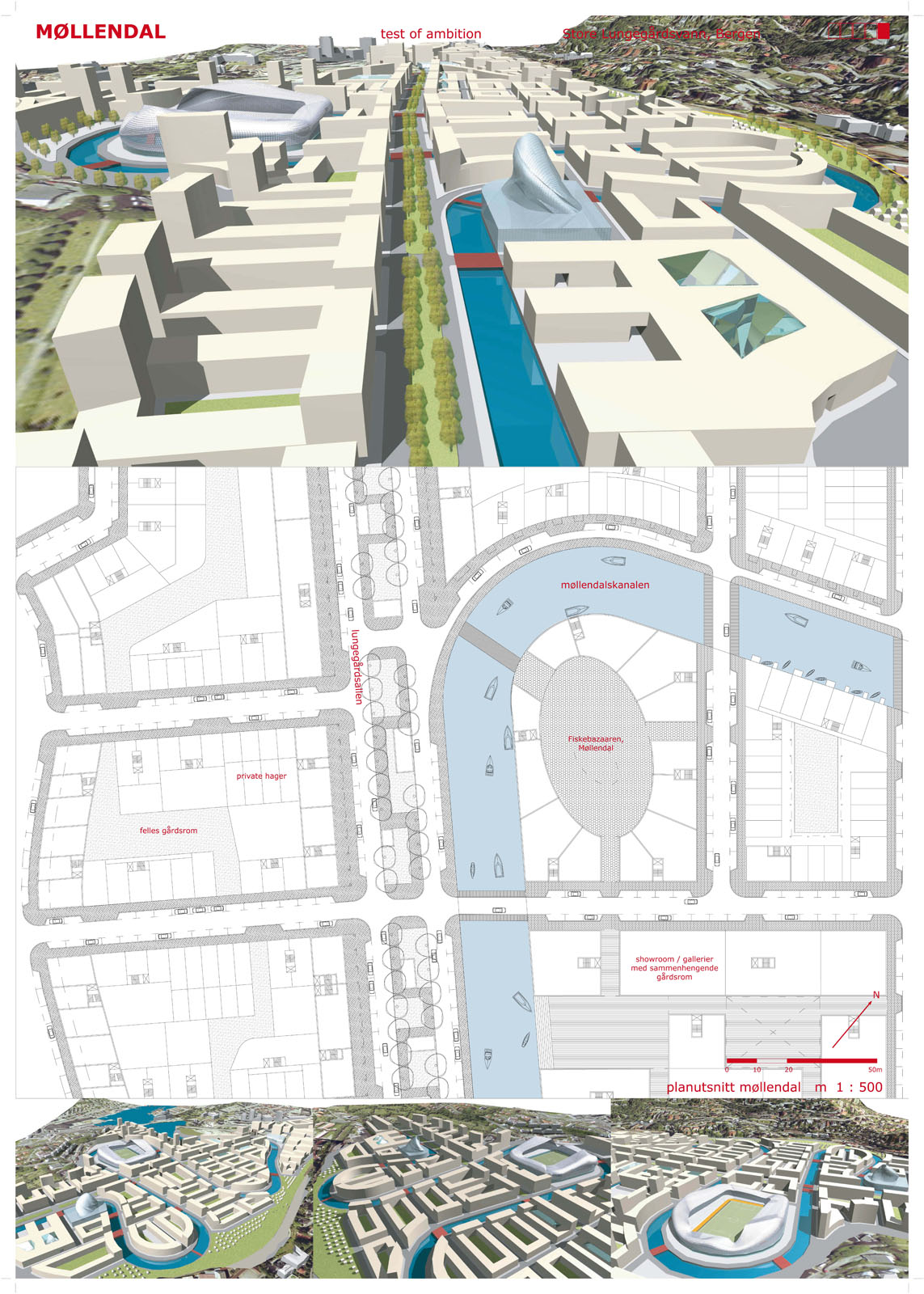
There are four central elements to the Plan: the bay, a park, a canal and a boulevard. The Bay: this was retained as the focual point of the area. A beach and forest edge were added to the North edge of the bay to create a pleasant park environment with maximum solar exposure. The Park: This expands upon a “wild” sown park that exists in the area. Widening it and drawing it along nearly the entire length of the site. Cabins are available for rental within the park for family outings. The park also is drawn into the last building stage “Gods teminal“. This creates a green transition between the hill side and the built environment. The Canal: The canal provides contact with water to the whole of the site. The snake like form of the canal also creates an interesting linear park environment for strolling or just relaxing in. The Boulevard: The Boulevard and Parkway is the central traffic element with in the site. It is lined with galleries such that pedestrians can move along this area with out being exposed to the weather. Further it ties into the regional tunnel system and provides and important access point for the entire site.
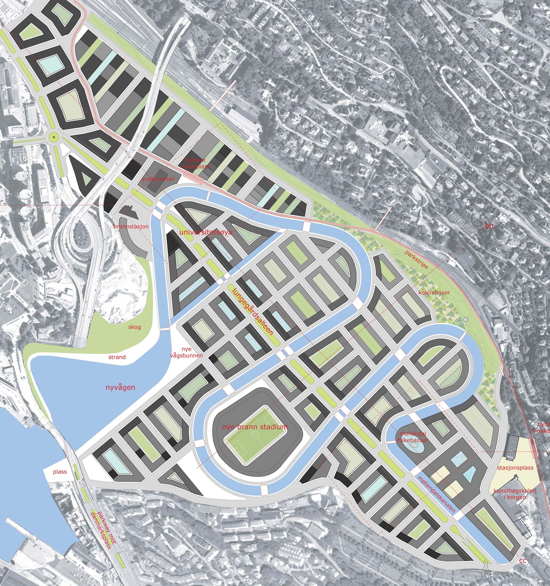
Site Plan
Building Heights:
Ground level drawn to be 4.5m and all other floors should have a 3.5m floor to ceiling height to ensure the flexible transition between office and residential space. The main streets are drawn to nine stories with the building mass stepping down to four stories toward the park on the North East side. Buildings taller than 9 stores are placed to reinforce the urban fabric at various locations. "A Test of Ambition" Finished Plan ca. 2060 (Darker Grey = Higher Building)
Program Elements:
Public Spaces: There are three major public spaces: Bay Side, Stadium and at the transit stop on the south edge. In addition to this there is an linear space that follows the canal. Green Spaces: Main (Wild) park that follow the length of the site. (note that it fingers into the last stage of development. The central Boulevard (parkway is similar to those in Berlin in size) provides green in the center of the city. Public Transport: Multiple Stops for bus and tram. Program: Includes Linear Housing (mixed use), Swimming Hall, University Island, Retail Center, Residential Area, Stadium, Market, Artist Lofts and Showrooms, Art School. Public Buildings and Schools: Art School, University, Sports High School, Grade School, Public Offices.

Site from the North Edge:
Time Frame:
Clearly a project of this scale is not possible in even a decade. Thus, the project was broken in to discrete steps that can be implemented over a period of multiple decades. This would also allow a known amount of new space to be available every year for expansion of services and housing. This timeline completes the plan in 2060, however the this open to adjustment in the decades to come.
Text from Entry:

View from East
1 Introduction:
This document will summarise the impact of and benefits from, our proposal for the “Test of Ambition” development project in Bergen. The feasibility of our proposal is based on an assessment of contemporary design and construction potentials (in consideration of industry experiences and technology trends), combined with an analysis of Bergen’s innate character and geographic position in the Europe. The potential advantages will be discussed based on this assessment, and have been cross-referenced with Bergen’s overall opportunities to grow and prosper over the next several decades. The project was conceived of with three primary goals in mind.
- First, to determine the most effective way to allow Bergen to grow within the confines of the areas geography.
- Second, to see if it were possible to improve the flow of the city and to make it more contiguous (By this we mean to address the issue of the city being somewhat fractured and having several distinct parts which do not readily coalesce for its inhabitants. Forming so called “continuous Urban Tissue”).
- Third, A long term plan that allows the city to grow in sections over a time. (In ten steps in up to 60 years).
- Finally, to design a development which would maximize Bergen’s potential for attractive growth in a way that preserved the unique charm of the city.


Our overall ambition is to create a development path which raises the opportunity for Bergen to gain anchorage not only as the primary location in Vestland, but as a premiere city in Scandinavia commensurate with its history and name recognition.

View from the South edge of the site:
2 General Benefits Case for our Proposal:
In the concept we propose, there are several major benefits that we believe make the project both desirable, and practical from a development perspective. Our assertions are based primarily on an analysis of those factors having to do with the unique character of Bergen. The resulting proposal is based on our determination in Bergen’s case, deriving the greatest value for the city will be achieved by channeling its strengths (i.e. pedestrian movement, diverse residential/commercial distribution etc) while at the same time addressing its primary weakness (its balkanized nature and limited possibilities for growth due to the areas geography).
1) The project would bring in about 25000 new inhabitants which would translate to a per annum increase in the income of the city proper (2004) 8-9 Billion NOK with its accompanying increase in the city tax revenue base. When multiplied by the standard x6 for "knock on" economic impact this would be the equivalent of 48 Billion NOK in increased economic activity per year in Bergen.
2) Our design allows the city to absorb these 25000 new inhabitants and a roughly equal amount of employment opportunities without unduly straining or compressing any of the existing aspects of Bergen’s infrastructure or neighborhood character.
3) The development accommodates several high value/high visibility sub-projects (a 30.000 person Stadium and “Big Box” retail opportunities) which will act to anchor key tenets and enhance Bergen’s status as an attractive place to live and work.
4) Both the proposed placement and its accompanying design have been devised to enhance the overall flow both for pedestrian and automotive traffic across Bergen as a whole, and particularly to help integrate the Downtown with Danmarksplass and its environs.
5) The proposed Tunnel system will be integrated with the development project (thus decreasing its cost), and is designed to address both existing issues faced by the city, and future growth potential.

View from North West
3 Specific Elements of the Proposed Project
There are several elements of the project, which we think merit special consideration even at this early concept stage. 1) One of the main design aspects of the actual physical design for the project which we wished to achieve was to retain the essential character of Store Lungegårdsvannet as a body of water. In this respect, the canal system is intended to achieve this with the significant benefit of having nearly every block in the development facing water. Additionally, the canal will permit small boat access to the outer harbour as well as create the opportunity for using the canal for recreation to move from one part of the development to another. The canal moves through the development in such a way as to effectively make the entire area waterfront, yet through strategically placed bridges the flow to both vehicles and pedestrians is virtually unimpeded.
2) The issue of traffic situation is addressed. On a typical day at present, over 35.000 vehicles go over the Nygårdstangen bridge, with peak periods absorbing the majority of daily volumes. This is the primary access for all traffic and any pedestrian traffic between downtown and Danmarksplass and the surrounding areas. This issue was addressed on several levels. The proposed tunnel system effectively spreads volume that presently concentrates on Nygårdstangen bridge over a much more logical pattern. Additionally, the path for commuters which presently requires out of the way driving patterns, can now be done more effectively for people that live in north or south of the centre. This will save time, cut down on fuel consumption and pollution, and generally improve the quality of life for these commuters. For local vehicles, access to and through the development is easy and robust enough to absorb spikes in volume for shopping and sporting events, with pedestrian traffic made quite easy and pleasant.
3) Commuting in and out of the area is readily addressed by light rail system which has the absorb large volumes of traffic. Further, this development increases the viability of the light rail system by providing significant numbers of riders: this could form an anchor for mass transit in Bergen. Lowering rider-ship costs and increasing frequency.
Infrastructure:
The plan for this area required a certain interventions in the regional infrastructure of Bergen, as much of this infrastructure crosses or is located on this site. Creation of limited access Regional Road (Europavei): The road network in Bergen consists of a roads that contain a mix of regional traffic and local traffic. This creates traffic problems disproportionate to the size of the city. “A Test of Ambition” proposes a long term plan to create a limited access motor way around the edge of the city. Due to the nature of Bergen topography this is conceived of as an extension of the tunnel network that is in place. (Red Dotted Lines) This would separate Local traffic from Regional Traffic. Further the material from this tunnel network could be used as fill for the sites within the bay of Store Lungegaardsvannet.

Section 2:
Dogma Architecture (Design Guidelines):
This is an attempt to ensure a mean level of “urbane” architecture despite the travesties of “style” and “expression” that contemporary architecture endures. (Dogma Architecture is a play on Danish Dogma School of film making.) Further, this “dogma” attempts to create an urban area with the possibility of use and reuse. Avoiding the tendency toward redundancy that is typical in contemporary architecture. In short how does one make a classical North European City?
1. All building should be integrated in to the surrounding urban fabric. That is buildings should conform to a set of shared proportions that are used by the city as a whole.
- 1.1 To this end all buildings in this development should have a ground floor of a minimum of 3.5m floor to ceiling.
- 1.2 The first 2-3 floors shall have an elaborated façade. Richer and more detailed material usage.
- 1.2.1 Façade shall have a minimum relief of 20cm.
- 1.2.2 The floors above the third floor may use common materials.
- 1.2.3 Main streets shall have colonnades to protect pedestrians form the elements. Min width 4.5m.
- 1.4 Buildings exterior wall must without exception follow the building line, and MH.
- 1.4.1 Important corners may be excepted from following the building line. However, they must then rise minimum 5m over the sidewalk surface.
- 1.4.2 This may be broken by bay windows or balconies over the third floor when permitted by zoning. These shall not exceed 1.2m in depth.
- 1.4.3 Spans must follow a clear rhythm. a-b-a-c, a-b-a
- 1.5 Building shall follow the typology indicated in the master plan.
- 1.5.1 These typologies are guidelines for use which the architect is expected to adapt for the site and function of the building.
- 1.5.2 Typologies must use entrance type that follow for that type of building.
- 1.6 “Big Box “ development is allowed along the parkway and Nyvågen areas. This however, must conform to the exterior volume or the building. Up to the first 3 ground floors my be built at TU100% to accommodate department stores or other large tenants. If TU 100% is used then min floor to ceiling height 4.5m floors 1-3)
- 1.7 Windows – All windows in public facades are to be constructed of superior materials and craftsmanship.
- 1.7.1 – There are to be no square windows of less than 2.7m on edge.
- 1.7.2 Windows should take in to consideration the nature of the site. Congested sites should have vertically oriented windows, (to ensure privacy) while less crowed area may use more open fenestration.
- 1.8 All building entrances shall be at street level.
- 1.9 Roof-scape: All building shall have an articulated roof structure.
- 1.9.1 There shall be a cornice on all roof edges.
- 1.9.2 The roof shall not extend beyond the exterior wall of the building. It must join to the exterior wall of the building.
- 1.9.3 Mansard style roof are permitted, but must always use top quality materials and elaborate detailing that is visible from the street level.
- 1.9.4 HVAC (VVS) Must be integrated into the design composition of the roof. It may not simply be placed in a box upon the roof.
2. Street design:
- Street furniture.
- 2.1 Street furniture should be placed as follows.
- 2.1.1All streets should have public lighting. This lighting should be well designed such that it does not over light the street area or cause unnecessary light pollution. A “soft ambient” feeling is desired.
- 2.2 Vegetation 10m interval.
- 2.3 Benches should be placed every 20m on central streets or public spaces on secondary they may be placed every 50m or on the corners. Dependent upon locality.
- 2.4 Rubbish bins shall be place every 15 meters on parkways or other central streets and public spaces. These shall not exceed 50 liters in volume. On corners and crossing places standard sized rubbish bins shall be placed.
3. All bridges. Are to be design by open competition, which are to be scheduled not more than biannually. No more than two bridges per competition.
- Public spaces:
- General statement: This project has very generous public spaces. It is not every project that can claim to have 51 blocks all facing water, park or some other public amenity. In many cases they face more than one of these attractions. Thus by necessity large squares and other public spaces have been minimized, replaced by the linear form. This also has an influence upon the design guidelines of the site. It is the purpose of this design to create a “splendid continuity”. Such as one finds in the execution of the Bergen 1916 plan. No single building stands out dramatically, however the quality of the space and scale are truly unique.
4. Canals / Plazas:
- 4.1 Canals are the single most important public space in this project. It forms the continuity and gives life to the project. It places the majority of sites on the water and forms an environment in which the pedestrian feels at home. This space has only one lane of traffic and generous sidewalks that allow people to stroll.
- 4.2 Benches and rubbish bins shall be placed as parkway.
- 4.3 Lighting should be unique for each public space.
Example of Architectural Types:
5 Exceptional designs.
- Experimental architecture is encouraged in landmark buildings or on exceptional sites in which the client is willing to commit an exceptional budget to enable such a project. These projects are to be judged by National, Nordic and International comities (depending on scale) in order to ensure the quality of the design.

SLGV west - View from West
Original Project Boards
Response:
There was quite a response from this project: it seemed to polarize people. Love and hate are not easy themes, so the politions of Bergen keep their hands clean and did not touch it. “A Test of Ambition” did strech the rules but it also was the only entry to provide a suggestion that had not been discussed before. I guess we will see how many flames land in the comments section. One kind soul did add this letter to Bergens Tiden (local news paper) opinion section. “Does Bergen have Ambition?”